Riverbank protection against erosion on the left bank of Day River in Hong Quang commune, Ung Hoa district
Project on Riverbank Protection Against Erosion on the Left Bank of Day River in Hong Quang Commune, Ung Hoa District
Decision No. 293/QD-KH&ĐT dated October 24, 2012
1. Project Information:
- Project name: Riverbank protection against erosion on the left bank of Day River in Hong Quang commune, Ung Hoa district
- Investor: Ung Hoa District People’s Committee
- Project consultant: Dai Viet Investment Consulting Joint Stock Company
- Project leader: Mr. Trinh Xuan Thien, Master of Engineering
2. Objectives:
- To prevent erosion and ensure safety for flood and storm prevention and safety for people, production land in the area as well as the left bank of Day River.
- To stabilize the life and promote production development for the people.
- To ensure environmental sanitation, beautify the landscape to meet the material and spiritual needs of the people in the project area.
3. Content and scale of investment:
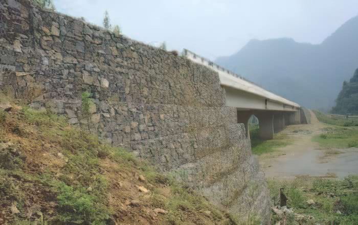
- Riverbank protection and stabilization with a total length of L = 959.35m (including 60m of stone retaining wall built around Bai Lam Ha pagoda).
- Section 1: From Trai Bo, Thanh Bo hamlet, Luu Hoang commune to the head of hamlet 1, Bai Lam Thuong hamlet, Hong Quang commune, with a length of 373.06m (corresponding to Km 78 +800 to Km 79+173,06 left bank of Day River).
- Section 2: From the head of hamlet 5, Bai Lam Ha hamlet, Hong Quang commune, with a length of 301.24m (corresponding to Km 80+689,66 to Km 80+ 990,90 left bank of Day River). This section has a retaining wall around the Bai Lam Ha pagoda area with a length of 60m.
- Section 3: From Mau Phan color field, hamlet 9, Bai Lam Ha hamlet, Hong Quang commune to the head of Nhat bridge, Bai Lam Ha, Hong Quang commune, with a length of 285.05m (corresponding to Km83+146,01 to Km83+431,06 left bank of Day River).
- The top of the embankment is combined as a concrete road M250# 20cm thick with a total length of 674.30m.
4. Construction location: Hong Quang commune, Ung Hoa district, Hanoi city.
5. Construction plan (basic design):
- Top of the embankment: Elevation of the top of the embankment ÷5.2; the top of the embankment is locked with a BTCT M250 beam with a cross-section of (30×40)cm.
- Embankment slope: Coefficient m=2, dry stone paving structure 30m thick in BTCT M200 frames (30×45)cm, under the dry stone paving there is a layer of (2×4)cm stone chips 10cm thick. At the eroded slope locations, the slope is built with compacted grade 3 soil with K = 0.95. The frame is divided into cells by BTCT M250, the longitudinal frame of the embankment, the frame in the middle divides the embankment slope into two sections (25×45)cm apart, 5m apart. Every 16m, a settlement slot is left, 03 5m wide steps are arranged along the embankment to serve people’s lives and inspection.
- Embankment body: 3m wide depending on the terrain, the embankment body is made of stone cages (2x1x0.5)m, with a 10cm thick layer of (2×4)cm stone chips underneath. Elevation of the top of the embankment body +1.00.
- Toe of the embankment: The toe of the embankment is made of a prism of boulders with an outer slope coefficient of m=2m.
- Inspection road: Arranged for sections 1 and 2. BTCT M250 structure 20cm thick on 3cm thick compacted sand, Grade 2 crushed stone foundation 14cm thick.
- Bai Lam Ha pagoda retaining wall: The retaining wall is made of boulders built with VXM M100#, the width of the top of the wall B=40cm, the outer slope is 4/1. The foundation is lined with (2×4)cm stone chips 10cm thick, and the foundation